IN THIS ARTICLE
Terrain World Debugger Component
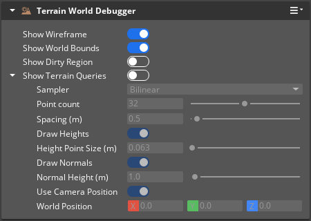
The Terrain World Debugger component offers a number of terrain debugging features. These visualizations are entirely optional, and can be toggled on or off individually.
Important:You must add this component to the Level entity, the parent of all entities in an Open 3D Engine (O3DE) level.
Provider
Dependencies
Properties
| Property | Description | Values | Default |
|---|---|---|---|
| Show Wireframe | Displays a wireframe representation of the Terrain World. | Boolean | Enabled |
| Show World Bounds | Displays the Terrain World bounds. | Boolean | Enabled |
| Show Dirty Region | Displays the most recent dirty region for the terrain. | Boolean | Disabled |
| Show Terrain Queries | Displays terrain query visualizations. | Boolean | Disabled |
Terrain Queries Configuration
| Property | Description | Values | Default |
|---|---|---|---|
| Sampler | The type of query sampler to use for querying the terrain values. | Exact, Clamp, or Bilinear | Bilinear |
| Point count | The number of points in each direction to visualize. | 1.0 - 64.0 | 32.0 |
| Spacing (m) | Determines how far apart the query results should be drawn in meters. | 0.001 - 10000.0 | 0.5 |
| Draw Heights | Enables visualization of terrain height queries. | Boolean | Enabled |
| Height Point Size (m) | Determines the size of the height point in meters. | 0.0 - 10000.0 | 0.0625 (1.0f / 16.0f) |
| Draw Normals | Enables visualization of terrain normal queries. | Boolean | Enabled |
| Normal Height (m) | Determines the height of the normal line in meters. | 0.0 - 10000.0 | 1.0 |
| Use Camera Position | Determines whether to use the current camera position or a specified position. | Boolean | Enabled |
| World Position | Center of the area to draw query results in. | Vector3: -Infinity to Infinity | X:0.0, Y:0.0, Z:0.0 |